本文来自微信公众号: IPP评论 ,作者:Mehri Madarshahi,原文标题:《Mehri Madarshahi|越过气候红线:当群山开始移动——发生在喜马拉雅的灾难与正在改变的气候风险地理》
导语:2026年8月26日,尼泊尔境内朗塘利荣峰发生大规模冰川崩塌,冰体与岩石从高处坠落,继而形成冰岩雪崩、泥石流和山洪,沿河谷向下游迅速传导,冲击中国西藏吉隆口岸,造成严重人员伤亡和财产损失。截至9月5日18时,中国吉隆口岸已有43人遇难、519人失联;尼泊尔已有1344人遇难、4898人失联。
喜马拉雅山脉是全球变暖最为敏感的区域之一。冰川加速消融、永久冻土持续退化,使高海拔山体稳定性不断降低;而高山冰川、陡峭坡面与深切河谷首尾相连的地形,又使得源头一处失稳,便能在极短时间内将风险传导至下游。类似的链式风险并非孤例——8月,台风“纳拉”袭击越南北部,强降雨引发洪水和山体滑坡,进而造成道路、基础设施和农作物受损,同样呈现出一条从气象事件到地质灾害再到基础设施破坏的风险传导链条。
IPP荣誉教授梅赫里·马达尔沙希(Mehri Madarshahi)将这种变化称为“不断变化的气候风险地理”:气候变化不仅在增加单一灾害发生的可能性,也在改变不同灾害之间的物理联系,使灾害发生的地点、传播的路径,以及暴露其中的人群和基础设施都随之发生变化。马达尔沙希教授提出,韧性建设不能只停留在灾后的应对、恢复和重建,而必须进一步前移到灾前的观察、预判、适应、保护和转型。她强调,如果风险的地理格局正在改变,那么韧性的地理格局也必须随之改变。
跨越气候红线:当群山开始移动
发生在喜马拉雅山脉的悲剧与其背后气候风险地理格局的变化
Beyond the Climate Red Line:When the Mountains Begin to Move
The Human Drama in the Himalayas and the Changing Geography of Climate Risk
IPP荣誉教授、联合国教科文组织下属国际创意和可持续发展中心(ICCSD)顾问委员会成员
2026年8月26日,喜马拉雅山脉的一部分开始移动。在尼泊尔与西藏交界附近的朗塘利荣峰高处,一大片冰川冰体和岩石突然崩裂,向下坠落逾千米,直冲谷底。其冲击力之大,以至于最初有人误以为发生了地震。
On 26 August 2026,part of a mountain in the Himalayas began to move.High on Langtang Lirung near the Nepal,Tibet border,an enormous mass of glacier ice and rock broke away and plunged more than a thousand metres into the valley below.The force was so great that the event was initially mistaken by some for an earthquake.
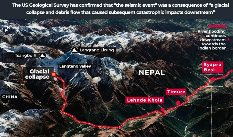
8月26日,尼泊尔朗塘利荣峰附近冰川发生大规模崩塌。大量冰体和岩石坠入谷底,随后演变为冰岩雪崩和泥石流,并沿河谷向下游引发灾难性洪水。图源:Reuters Graphics
然而,这场崩塌的影响并未止于最初发生的地点。数百万吨冰体和岩石沿山坡加速下泄,并在途中不断裹挟泥沙、碎屑和水体。雪崩由此演变为泥石流。随后,泥石流进入河流系统,以惊人的速度继续向下游推进,将破坏带向距离最初崩塌地点数十公里之外的社区和基础设施。
But the collapse did not end where it began.As millions of tonnes of ice and rock accelerated downhill,they gathered sediment,debris and water.An avalanche became a debris flow.The flow entered the river system and continued downstream at extraordinary speed,carrying destruction toward communities and infrastructure many kilometres from the original collapse.
短短几分钟,整座山谷的地貌便已改变。
Within minutes,the geography of the valley had changed.
冰川崩塌,山体失稳。冰与岩石汇成泥石流,河流转眼化作奔涌的泥浆。灾难几乎在瞬间降临。但这场灾难也提出了一个更大的问题:当气候变化开始改变的不再只是天气,而是我们赖以生存的自然地貌本身时,又会发生什么?
The glacier collapsed.The mountain gave way.Ice and rock became a debris flow.A river became a wall of mud.The human tragedy was immediate.But the catastrophe also raises a larger question:what happens when climate change begins to alter not simply our weather,but the physical landscape itself?
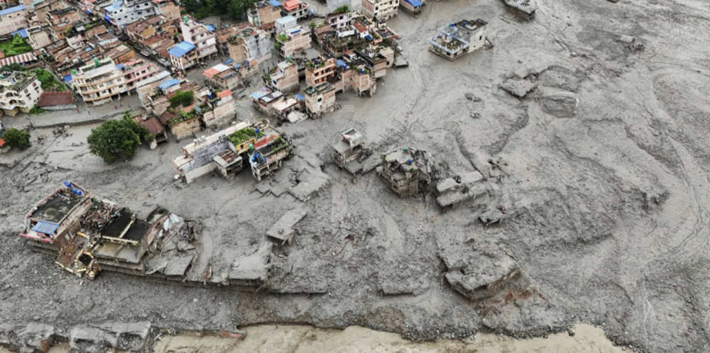
8月27日,无人机拍摄的画面显示,尼泊尔努瓦科特地区山洪暴发后,房屋被泥土覆盖。图源:路透社
当冰冻世界开始融化
When the Frozen World Begins to Thaw
这个问题之所以重要,是因为喜马拉雅地区正在经历深刻变化。大气中的二氧化碳浓度,已从工业化前约278ppm(百万分之一)上升至如今的423ppm(百万分之一)以上,这一水平至少在过去200万年中前所未有。温室气体持续累积所带来的影响,如今已在全球范围内清晰显现:世界各地的冰川正在退缩,格陵兰和南极冰盖持续失冰,永久冻土不断融化,海洋持续升温,海平面也在不断上升。
The question matters because the Himalayas are undergoing profound change.Atmospheric carbon dioxide has risen from about 278 parts per million before industrialisation to more than 423 ppm today,a concentration unprecedented in at least two million years.The consequences of this accumulation of greenhouse gases are now visible across the planet.Glaciers are retreating worldwide,Greenland and Antarctica are losing ice,permafrost is thawing,oceans are warming and sea levels are rising.
喜马拉雅正是这场全球性变化的一部分。1990年至2020年间,兴都库什—喜马拉雅地区的冰川面积减少了约12%,估算冰储量减少了约9%。但冰川消融只是这一变化最直观的表现。
The Himalayas are part of this planetary transformation.Between 1990 and 2020,glaciers across the Hindu Kush Himalayan region lost about 12 percent of their area and approximately 9 percent of their estimated ice reserves.But disappearing ice is only the most visible consequence.
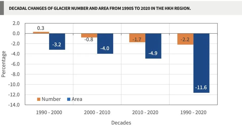
兴都库什—喜马拉雅地区冰川数量与面积变化。30年间,该地区冰川面积累计减少11.6%,其中2010—2020年降幅达到4.9%,高于此前两个十年。图源:ICIMOD
冰体本身,也在维系着山体的稳定。
Ice also helps hold mountains together.
在高海拔地区,永久冻土深入基岩的裂缝之中,如同“胶水”一般帮助稳固陡峭的山体。随着气温升高,这种冻结的“胶水”开始融化,水分逐渐渗入裂隙,悬冰川不断退缩并失去支撑,而原本形成于一种气候条件下的岩壁,也越来越多地面临变化的气候环境。
At high elevations,permafrost penetrates cracks and fissures in bedrock,helping stabilise steep mountain faces.As temperatures rise,this frozen“glue”begins to thaw,water penetrates fractures,hanging glaciers retreat and lose support,and rock faces that developed under one climatic regime increasingly confront another.
科学家目前仍在研究8月26日山体失稳的确切原因。近期调查显示,长期的冰川运动、春夏季异常偏暖、融水增加以及高海拔永久冻土退化,都可能削弱了冰体与岩石之间的接触带。
Scientists are still reconstructing precisely what produced the August 26 failure.Recent investigations point to long-term glacier movement,unusually warm spring and summer conditions,increased meltwater and degradation of high-altitude permafrost as factors likely to have weakened the ice-rock contact zone.
气候变化未必需要直接“推下第一块岩石”,也足以改变那些使山体变得脆弱的环境条件。
Climate change need not push the first rock down the mountain to have transformed the conditions that made the mountain vulnerable.
也正是在这一点上,尼泊尔这场灾难所揭示的,已经远不止一次山体崩塌本身。
And that is where the Nepal catastrophe begins to tell us something much larger.
正在改变的风险地理
A Changing Geography of Risk
在人类历史的大部分时间里,地理环境都具有某种程度的稳定性。山依然是山,河流大体沿着可以辨识的河道流淌,冻土长期保持冻结,海岸线的移动也足够缓慢。因此,人们能够逐渐了解哪里容易发生洪水、哪些山坡存在危险,以及通常可以从哪里获得水源。现代文明在很大程度上正是建立在这些相对稳定的假设之上。
For most of human history,geography has provided a certain degree of permanence.Mountains remained mountains,rivers occupied broadly recognisable corridors,frozen ground remained frozen and coastlines moved slowly enough for communities to learn where floods occurred,which slopes were dangerous and where water could normally be found.Much of modern civilisation was built upon those assumptions.
气候变化正开始打破这些稳定的状态。
Climate change is beginning to disturb them.
更温暖的大气能够容纳更多水汽,从而增加极端降雨发生的可能性;与此同时,更高的气温会加速冰川退缩和永久冻土融化。高温和长期干旱使森林、植被和土壤变得干燥;海平面上升改变海岸线;降水变化则会影响河流、水库和水资源供应。
A warmer atmosphere can hold more moisture,increasing the potential for extreme rainfall,while higher temperatures accelerate glacier retreat and permafrost thaw.Heat and prolonged drought dry forests,vegetation and soils;rising seas alter coastlines;and changing precipitation affects rivers,reservoirs and water supplies.
更重要的是,这些变化并不是彼此独立发生的。
More importantly,these changes do not remain neatly separated from one another.
一次冰川失稳可能演变成雪崩,雪崩又可能转化为泥石流,泥石流最终还可能引发洪水。极端降雨可能导致坡体失稳,由此引发的滑坡可能堵塞河道,而这种临时形成的堰塞体一旦最终溃决,就可能给下游社区造成毁灭性破坏。干旱和高温会使植被变得干燥,并加剧野火发生的条件;火灾随后又可能烧毁坡面植被、改变土壤状况,使同一片区域在降雨最终再次到来时,更容易遭受洪水和泥石流侵袭。
A glacier failure can become an avalanche,the avalanche a debris flow and the debris flow a flood.Extreme rainfall can destabilise a slope,the resulting landslide can block a river,and the eventual failure of that temporary barrier can devastate communities downstream.Drought and heat can dry vegetation and intensify wildfire conditions;fire can then strip a slope of vegetation and alter its soils,leaving the same landscape more vulnerable to flooding and debris flows when rain eventually returns.
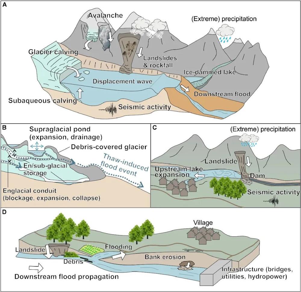
高山地区级联灾害示意图。冰川、冰湖、滑坡、雪崩和洪水等灾害可能通过相互触发形成连续的灾害链,并将风险进一步传导至下游社区和基础设施。图源:Frontiers in Earth Science
因此,气候变化所带来的影响,已经不只是增加单一灾害发生的风险。它还在改变不同灾害之间的物理联系。
Climate change is therefore doing more than increasing individual hazards.It is changing the physical relationships among them.
这正是我所说的“不断变化的气候风险地理”:在这样一个世界里,灾害从何处发生、沿什么路径传播,以及哪些人群和基础设施暴露于风险之中,都正在随着气候变化而发生改变。
This is what I call the changing geography of climate risk:a world in which the places where hazards originate,the pathways through which they travel and the people and infrastructure exposed to them are being altered by a changing climate.
喜马拉雅地区是一个极具代表性的例子,但绝非唯一的例子。
The Himalayas provide a dramatic example.But they are not alone.
从水太多到水太少
From Too Much Water to Too Little
中国直观地展现了这种风险地理变化的另一面。喜马拉雅地区的灾难始于尼泊尔与西藏边境高处的冰冻地带,而中国其他一些地区近期面对的,却是异常大量的降水。与热带天气系统相关的暴雨引发了洪水、山体滑坡和大规模人员疏散,表明降雨可以多么迅速地从一种气象事件演变为地质灾害,继而转化为人道紧急事件。
China provides an immediate illustration of the other face of this changing geography.While the Himalayan catastrophe began in frozen terrain high above the Nepal–Tibet border,other parts of China have recently confronted extraordinary amounts of water.Torrential rainfall associated with tropical systems has produced flooding,landslides and mass evacuations,demonstrating how quickly rainfall can move from meteorological event to geological hazard and then to human emergency.
其重要之处并不只在于降雨量本身,而在于由此引发的一系列连锁后果。水分使土壤趋于饱和,坡体随之失稳;山体滑坡破坏房屋和道路;河流漫溢;交通网络中断;甚至远离风暴中心的社区,也可能被卷入不断扩大的风险地理之中。
The significance lies not simply in the amount of rain.It lies in the chain of consequences.Water saturates soil;slopes become unstable;landslides damage homes and roads;rivers overflow;transport networks are interrupted;and communities that may lie far from the centre of a storm find themselves inside its expanding geography of risk.
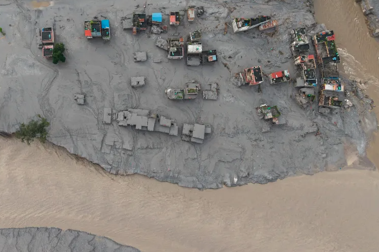
2026年8月27日,尼泊尔努瓦科特县比杜尔市德维加特,特里舒利河与塔迪河交汇处发生山洪后,大量房屋被泥浆淹没。图源:AFP
然而,从中国一路向西来到欧洲,问题几乎呈现出相反的面貌。
Travel westward from China to Europe,however,and the problem can appear almost reversed.
2026年夏季,欧洲大片地区经历了异常严重的高温和干旱。卢瓦尔河、波河、莱茵河和多瑙河等主要河流水位降至异常低的水平,而干燥的植被和土壤则进一步加剧了严重的野火风险。其影响远远超出了自然环境本身:河流水位偏低影响了航运和供水,冷却用水不足以及水力发电量下降,也给能源系统带来了压力。
The summer of 2026 brought extraordinary heat and drought across large parts of Europe.Major rivers including the Loire,Po,Rhine and Danube fell to exceptionally low levels,while dry vegetation and soils contributed to severe wildfire conditions.The consequences moved well beyond the environment:low river flows affected navigation and water supply,while shortages of cooling water and reduced hydropower generation placed pressure on energy systems.
法国提供了一个尤其鲜明的例子。2026年夏季是法国自1900年开始全国气象记录以来最炎热的夏季。多轮热浪与严重的降水不足、异常干燥的土壤以及破坏性野火同时出现。
France offers an especially striking example.The summer of 2026 was the hottest recorded there since national records began in 1900.Repeated heatwaves coincided with severe rainfall deficits,exceptional soil dryness and damaging wildfires.
同样,这里的关键并不只是“高温”或“干旱”,而在于二者之间的相互作用。高温加剧蒸发,干旱使土壤和植被失去水分,干燥的植被成为野火的燃料;河流水量减少则影响交通运输和电力生产。同一种气候压力由此传导至农业、生态系统、公共健康和经济等多个领域。
Here again,the important story is not simply“heat”or“drought.”It is their interaction.Heat increases evaporation,drought removes moisture from soil and vegetation,dry vegetation becomes fuel for wildfire,diminished rivers affect transport and electricity generation,and the same climatic stress travels through agriculture,ecosystems,public health and the economy.
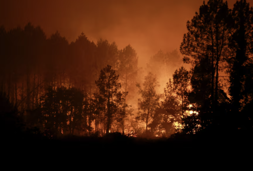
2026年8月14日,法国吕格隆(Luglon)发生野火,火焰吞噬树林。图源:路透社
因此,气候风险的地理格局正在朝着看似相互矛盾的方向发生变化:一些地方遭遇的是破坏性的水量过剩,另一些地方面对的则是危险的水资源匮乏。两者背后的共同因素,是一个正在积聚更多能量和水汽的气候系统,它正在改变社会赖以组织和运行的环境条件。
The geography of climate risk is therefore changing in apparently contradictory directions.In one place there may be destructive excesses of water;in another,a dangerous absence of it.The common denominator is a climate system accumulating additional energy and moisture and altering the environmental conditions around which societies organised themselves.
这种变化还在进一步延伸。北美和欧洲部分地区的干旱与创纪录高温,正使森林承受越来越大的压力,不仅加剧野火风险,也导致森林衰退,并使其更容易受到虫害和疾病侵袭。与此同时,在世界各地的海岸线上,海平面上升和侵蚀正逐渐改变陆地与海洋之间的边界,而社区、港口和基础设施仍然停留在最初建设的位置。
The pattern extends further.Across North America and parts of Europe,drought and record heat are placing forests under increasing stress,contributing not only to wildfire danger but also to forest dieback and vulnerability to pests and disease.Around the world's coastlines,rising seas and erosion are gradually shifting the boundary between land and water,while communities,ports and infrastructure remain where they were built.
将这些现象联系在一起的,并不是地理上的接近,而是物理环境本身的转变。
What links these experiences is not geographical proximity.It is physical transformation.
未来已经到来
The Future Has Arrived
围绕这种转变的科学证据,已经越来越难再被视为彼此孤立的预警信号。2015年至2025年的11年,是有观测记录以来最热的11年。2025年,海洋热含量再次创下纪录,而大气中的温室气体浓度也继续维持在前所未有的水平。
The scientific evidence surrounding that transformation is becoming increasingly difficult to separate into isolated warning signs.The eleven years from 2015 to 2025 were the warmest eleven years in the observational record.Ocean heat content reached another record in 2025,while atmospheric greenhouse-gas concentrations remained at unprecedented levels.
全球主要山地地区的冰川都在持续退缩,格陵兰和南极冰盖也在不断失去质量。与此同时,热量和降水模式的变化,正在影响距离冰冻地区数千公里之外的森林、河流、农业系统和人类聚居区。
Glaciers are retreating across the world's major mountain regions as the Greenland and Antarctic ice sheets continue losing mass.At the same time,changing heat and precipitation patterns are affecting forests,rivers,agricultural systems and human settlements thousands of kilometres from the frozen regions.
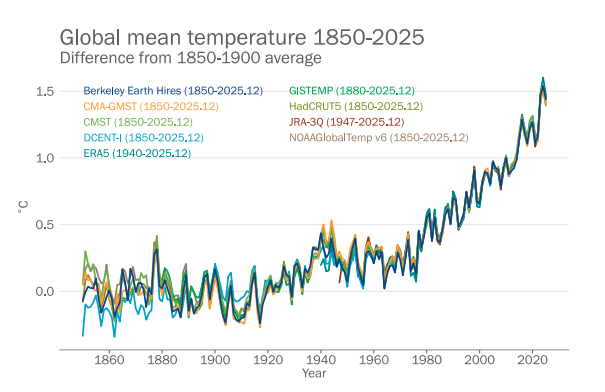
1850—2025年全球平均近地表温度变化。2025年全球平均气温较1850—1900年工业化前水平高约1.43℃,2015—2025年为有观测记录以来最暖的连续11年。图源:世界气象组织(WMO)
我们面对的已经不再是一些零散的信号,而是一个正在发生变化的地球系统。
We are no longer looking at scattered signals.We are looking at a changing Earth system.
而这或许正是最大的难题所在。
And therein lies perhaps the greatest difficulty.
人类文明在空间上具有高度的固定性。政治边界大体仍停留在最初划定的位置,城市、道路、桥梁、水坝、港口和发电站也依然位于最初建设的地方。用于保护这些设施和聚居区的地图、工程标准和规划假设,也大多建立在对过去环境条件的观察之上。
Human civilisation is remarkably fixed in space.Political borders remain largely where they were drawn,while cities,roads,bridges,dams,ports and power stations remain where they were built.The maps,engineering standards and planning assumptions designed to protect them were developed largely from observations of the past.
但它们周围的物理环境正在变得越来越不稳定。一些地区正出现超出预期的水量,而另一些地区缺水持续的时间却越来越长;随着冰川退缩,冻土正在融化;持续高温正在改变森林和地貌;海平面上升则逐步推动海岸线发生变化,而沿海聚居区却无法简单地随之迁移。
But the physical environment around them is becoming less stationary.Water is appearing in unexpected quantities in some regions while disappearing for longer periods from others;frozen ground is thawing as glaciers retreat;prolonged heat is changing forests and landscapes;and rising seas are gradually shifting coastlines against settlements that cannot simply move with them.
未来已经到来——它并不是以某一场单独的气候灾难降临,而是表现为人类文明赖以运行的整个物理环境正在发生转变。
The future has arrived—not as one climatic catastrophe,but as a transformation of the physical environment within which human civilisation operates.
当韧性必须走在灾难之前
When Resilience Must Come Before Disaster
这就把我们带到了“韧性”这一问题。
This brings us to resilience.
长期以来,人们主要把韧性理解为从灾难中生存下来,以及灾后的恢复与重建。这些能力依然至关重要,但它们都是在问题已经发生之后才开始发挥作用。
For too long,resilience has been associated principally with surviving disaster,recovering and rebuilding.Those capacities remain essential,but they begin after something has already gone wrong.
这已经不够了。
That is no longer sufficient.
如果我们不能再理所当然地认为,昨天的物理环境到明天仍会保持不变,那么,在昨天的位置重建昨天的基础设施,可能只是在复制明天的脆弱性。
If yesterday's physical conditions cannot automatically be assumed tomorrow,rebuilding yesterday's infrastructure in yesterday's locations may simply reproduce tomorrow's vulnerability.
因此,韧性必须从灾难发生之前开始。它意味着观察环境变化,预判风险正在向哪里移动,调整基础设施和土地利用方式,保护脆弱群体,并在必要时改变我们建设的方式和地点。
Resilience must therefore begin before disaster.It must mean observing environmental change,anticipating where risk is moving,adapting infrastructure and land use,protecting vulnerable communities and,where necessary,transforming how and where we build.
传统的路径往往是:
灾难→应对→恢复→重建
The conventional sequence has too often been:Disaster→Response→Recovery→Reconstruction.
而正在形成的气候现实要求采取另一种路径:
观察→预判→适应→保护→转型
The emerging climatic reality requires something different:Observe→Anticipate→Adapt→Protect→Transform.
这并不只是措辞上的区别。它改变的是社会何时采取行动,以及究竟要为什么做好准备。
The distinction is not semantic.It changes when societies act and what they prepare for.
喜马拉雅地区尤其清楚地说明了这一点。一个村庄并不需要紧邻冰川,才会暴露于冰川风险之中。它可能位于数十公里之外的下游,却通过山坡、河流、道路或水电系统与冰川相连。同样的道理也适用于其他地方:一座城市即便没有直接被野火烧毁,如果火灾破坏了它的集水区,同样会承受野火带来的后果;一个工业中心即便没有直接遭遇干旱,如果河流水位下降中断了它所依赖的交通或能源系统,同样会受到影响。
The Himalayas make this particularly clear.A village does not need to stand beside a glacier to be exposed to glacial risk.It may lie tens of kilometres downstream,connected to the glacier by a slope,a river,a road or a hydropower system.The same principle applies elsewhere:a city does not need to burn to suffer the consequences of wildfire if fire damages its watershed;nor does an industrial centre need to experience drought directly if falling river levels interrupt the transport or energy systems upon which it depends.
因此,朗塘利荣峰的悲剧留给我们的,是一个远比“究竟是什么导致一处山体崩塌”更大的问题。
The tragedy of Langtang Lirung therefore leaves us with a question far larger than what caused one mountain face to collapse.
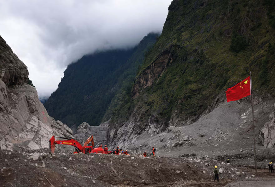
9月6日,救援人员在中国西藏自治区日喀则市吉隆口岸核心受灾区开展救援工作。图源:路透社
它所追问的是:我们对风险的认识,是否正在以与周围物理世界变化同样快的速度发生改变?
It asks whether our understanding of risk is changing as rapidly as the physical world around us.
气候变化并不会移动政治边界,但它正在推动一些人类文明赖以存在的物理边界发生变化:冰与水之间的边界、冻结与融化之间的边界、河流与聚居区之间的边界、森林与火灾带之间的边界,以及可居住海岸与不断逼近的海洋之间的边界。
Climate change does not move political borders,but it is moving some of the physical boundaries upon which civilisation has depended:between ice and water,frozen and thawed ground,river and settlement,forest and fire zone,and habitable coast and encroaching sea.
如果风险的地理格局正在改变,那么韧性的地理格局也必须随之改变。
If the geography of risk is changing,the geography of resilience must change with it.
当冰川不断退缩、河流突破其历史边界、森林变得更加易燃,甚至山体也开始移动时,如果还要等到灾难发生之后才开始适应,那就已经不能称之为韧性。
When glaciers retreat,rivers exceed their historical boundaries,forests become more combustible and mountains begin to move,waiting for catastrophe before adapting is no longer resilience.
那时,就已经太迟了。
It is already too late.
梅赫里·马达尔沙希(Mehri Madarshahi)
华南理工大学公共政策研究院(IPP)荣誉教授、联合国教科文组织下属国际创意和可持续发展中心(ICCSD)顾问委员会成员
Honorary Professor of The Institute of Public Policy(IPP),South China University of Technology(SCUT);